Thar She Flows
A physics professor probes the magma beneath one of the nation’s most dangerous volcanoes.
LIKE MOST VOLCANOES, Washington’s Mount Rainier serenely sits atop a slow motion train wreck, as pieces of the earth’s crust collide and buckle miles below. Scientists know that this tectonic plate mash-up creates the magma that feeds the still-active volcano. But the question of what path the magma takes from its subterranean origins to Mount Rainier’s peak has long been a mystery.
Now, new research by Assistant Professor of Physics R Shane McGary and three colleagues offers an unprecedented look into what’s brewing beneath Mount Rainier. The team’s findings, published last summer in the journal Nature, could help scientists gain a better grasp of how magma moves beneath volcanoes, and determine which should be labeled as potential threats.
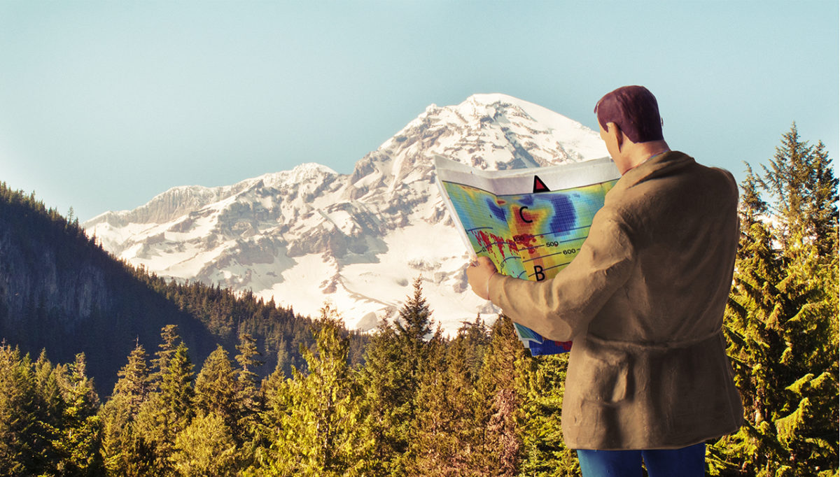
To map Mount Rainier’s magma flow, the researchers combined previously collected seismic data with data they collected using magnetotellurics, a newer technique that measures electromagnetic activity deep within the earth. Similar to the way a metal detector finds hidden treasure buried under sand, magnetotellurics images electrically conductive molten magma within the earth.
Using a network of sensors and electrodes to probe depths of up to 75 miles beneath Mount Rainier’s base, the researchers detected a giant slab of oceanic crust coming in from the Pacific and colliding with the portion of continental crust that is western Washington State. Where the two come into contact is the origin of the molten rock that flows upward, in a giant column, toward the base of Mount Rainier.
The team also discovered a gaping reservoir—5 to 10 miles wide and equally tall—that holds magma just a few miles beneath the volcano’s base. McGary, lead author of the Nature report, noted how this architecture differs from what’s under other volcanoes in the area. Nearby Mount Jefferson in Oregon, for example, lacks Mt. Rainier’s distinct plume—or flow path—for magma.
“This evidence supports the idea that Mount Rainier is more of a short-term eruption threat than Mount Jefferson,” he says. Mount Rainier, which towers over millions in the Seattle-Tacoma area, last erupted in 1894, but the U.S. Geological Survey believes it will erupt again. While the new plumbing imagery from McGary’s team can’t be used to predict when (see sidebar), it does contribute to knowledge about how magma moves on the way to an eruption.
“The flow of magma from the oceanic slab to the surface has to be fairly quick—as in, hundreds rather than thousands of years,” says McGary. “We can’t say when a volcano is going to erupt, but certainly we can predict which volcanoes are going to cause issues in the near future.”
The two plates butting heads beneath Mount Rainier are the Juan de Fuca plate, an oceanic plate, and the massive North American continental plate. In this geological match-up, the continental crust wins out due to the higher density of the oceanic crust. As a result, the Juan de Fuca plate is being driven underneath into the hot, dense mantle layer below.
As the oceanic plate becomes more immersed in the mantle, the high heat and pressure cause some of its water to release. The water melts the surrounding rock, converting it into molten magma, which flows upward to form volcanoes. In the case of Mount Rainier, the pathway is more or less straight up, from the slab to the peak, the researchers found.
“The oceanic plate is being driven down below the United States, and that’s what causes the volcanoes to form in the first place,” says McGary. “The continents do move, and the process is really dynamic.” With the Mount Rainier study concluded, McGary wants to use a similar process—combining seismic data and magnetotelluric imaging—to look back in time.
“When the supercontinent Pangaea split apart about 200 million years ago, Africa left part of itself behind as a gift,” says McGary. That “gift” is the present-day state of Florida, and McGary hopes to discover more about the suture that once connected the two continents. —Meeri Kim
CAN WE PREDICT ERUPTIONS?
Although we now know what Mount Rainier’s volcanic plumbing looks like, when it will blow next remains a mystery. The type of imaging McGary and his colleagues used, magnetotellurics, can help scientists better understand how volcanoes operate in general—and which could cause problems in the near future—but it can’t yet pinpoint eruptions.
“To get a clear picture of what is going on 80 kilometers down, we need a few weeks’ worth of data,” says McGary. You’d also need faster computers to analyze the data. But as technology advances, and processing speeds improve, something closer to “real-time” imaging could only be decades away.
We’ve gotten better at forecasting eruptions, McGary says. “When Mount Pinatubo in the Philippines erupted in 1991, the monitoring of seismic activity that preceded the eruption led to an evacuation that saved thousands of lives.” But predicting eruptions is far from an exact science, especially since not all volcanoes give seismic warnings before blowing their tops.
Posted on February 20, 2015